 En route to Cape San Agustin,
we had a brief stopover at the coastal village of Montserrat. On a clear day, the village would have looked
picturesque when captured in photos but on that gloomy afternoon it seemed rather
drab and dull. Still, we managed to take a few shots of that part of the town.
En route to Cape San Agustin,
we had a brief stopover at the coastal village of Montserrat. On a clear day, the village would have looked
picturesque when captured in photos but on that gloomy afternoon it seemed rather
drab and dull. Still, we managed to take a few shots of that part of the town.
 From
Montserrat, our next stop was the sleepy village of Magdug where we were
enthralled to see a gargantuan tree that’s said to be three hundred years old!
For the next few minutes, it was once again photo ops time for the adventure-seeking
bunch.
From
Montserrat, our next stop was the sleepy village of Magdug where we were
enthralled to see a gargantuan tree that’s said to be three hundred years old!
For the next few minutes, it was once again photo ops time for the adventure-seeking
bunch.

 Wasting no time, we drove farther
towards the southernmost town of GovGen where the awesome Cape San Agustin is
found: Lavigan. For the most part, I felt comfy as we trod the paved portion of
the Tibanban-Lavigan coastal road but when the bumps and humps became constant and
the unpaved paths turned dangerously narrow, a twinge of anxiety suddenly
welled up inside me. What if one of the drivers made the wrong move and plunged
the vehicle deep into the ravines? I shivered at the possibility. Pushing the
morbid thought out of my mind, I tried to catch some sleep.
Wasting no time, we drove farther
towards the southernmost town of GovGen where the awesome Cape San Agustin is
found: Lavigan. For the most part, I felt comfy as we trod the paved portion of
the Tibanban-Lavigan coastal road but when the bumps and humps became constant and
the unpaved paths turned dangerously narrow, a twinge of anxiety suddenly
welled up inside me. What if one of the drivers made the wrong move and plunged
the vehicle deep into the ravines? I shivered at the possibility. Pushing the
morbid thought out of my mind, I tried to catch some sleep.

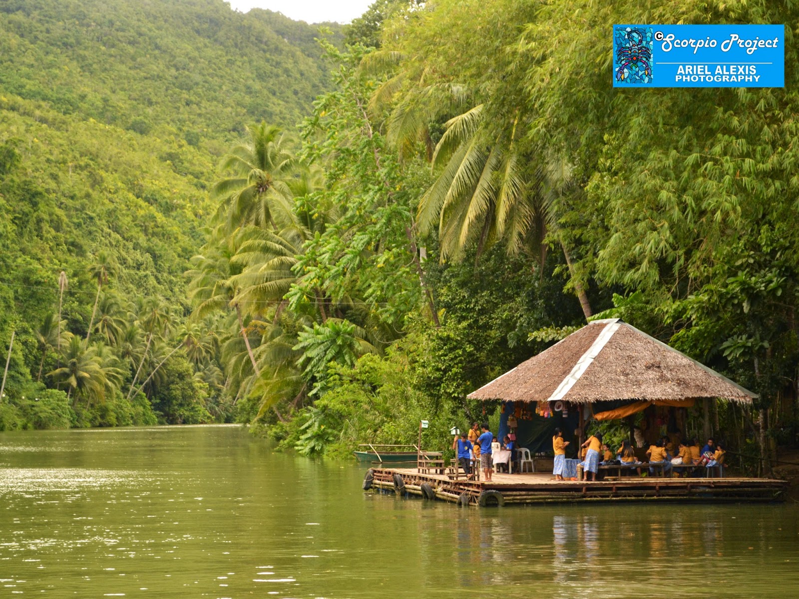
 Two hours down the road, the
vans came to a stop. The drivers said they could only take us up to that point.
This meant we had to hike for about thirty minutes to get to the lighthouses of
Cape San Agustin. The sloping trail to the lighthouses was far from a bed of
roses as the rain had made it muddy and slippery. Still, we forged ahead, inching
our way up into the clearing. Later, we reached the spot where we rested and
had our snacks.
Two hours down the road, the
vans came to a stop. The drivers said they could only take us up to that point.
This meant we had to hike for about thirty minutes to get to the lighthouses of
Cape San Agustin. The sloping trail to the lighthouses was far from a bed of
roses as the rain had made it muddy and slippery. Still, we forged ahead, inching
our way up into the clearing. Later, we reached the spot where we rested and
had our snacks.
 |
| The Last Islet |

 Cameras flashed and tablets
clicked once more as the group gravitated towards the Parola and posed all over
the place for what seemed like eternity, if only for posterity’s sake.
Having
enough of the lighthouses, Olan led us to the edge of the promontory where we had
a glimpse of what is known as The Last Islet, a tiny speck of land that stood
apart from the edge of the cliff. There, we saw the point where the calm waters
of Davao Gulf on the west converge with the raging waters of the Celebes Sea on
the south and the wild ones of the Pacific Ocean on the east. Geez, it was such
a mind-blowing spectacle! More picture-takings followed.
Cameras flashed and tablets
clicked once more as the group gravitated towards the Parola and posed all over
the place for what seemed like eternity, if only for posterity’s sake.
Having
enough of the lighthouses, Olan led us to the edge of the promontory where we had
a glimpse of what is known as The Last Islet, a tiny speck of land that stood
apart from the edge of the cliff. There, we saw the point where the calm waters
of Davao Gulf on the west converge with the raging waters of the Celebes Sea on
the south and the wild ones of the Pacific Ocean on the east. Geez, it was such
a mind-blowing spectacle! More picture-takings followed.
Unfortunately, inclement
weather and inadequate time kept us from exploring Cape San Agustin’s
wonderful rock formations on the other end of the coastline towards the village
of Pundaguitan. One of these formations, the so-called “Altar”, is said to have
been the lone mute witness to the foundation of Christianity in the province
where St. Francis Xavier allegedly celebrated the Holy Mass when he set foot in
Mindanao in 1550! Sounds too good to be
true, eh?
 While it’s been written by
17th century writers that the saint landed in the island during his expedition
to the Moluccas, I have my misgivings. That’s why I added “allegedly” because
it’s never been proven beyond reasonable doubt that he indeed reached the place
and preached the Gospel in that part of the Philippines, based on accounts of the
Catholic Encyclopedia. With or without St. Francis Xavier going there, however,
I’m poised to return to that part of the town if only to see those rocks. But
that, I guess, must have to wait until the road going there has been fully concreted.
While it’s been written by
17th century writers that the saint landed in the island during his expedition
to the Moluccas, I have my misgivings. That’s why I added “allegedly” because
it’s never been proven beyond reasonable doubt that he indeed reached the place
and preached the Gospel in that part of the Philippines, based on accounts of the
Catholic Encyclopedia. With or without St. Francis Xavier going there, however,
I’m poised to return to that part of the town if only to see those rocks. But
that, I guess, must have to wait until the road going there has been fully concreted.
 From the Parola, we left for
the beach below the promontory. Known for its pink grains of powdery sand,
Parola Beach had me the moment I stepped into its virginal shores, which appeared
more like peach to me that day because of the gloomy weather. Bashed by the raging
waves of the Pacific Ocean, the beach was one of the highlights of the tour,
mitigating the vexations I felt during the two-hour ride to Lavigan. Many of us
took a quick dip into the cold waters of the deep blue sea if only to shake off
from our tired bodies the dust, dirt and distress of the trip.
From the Parola, we left for
the beach below the promontory. Known for its pink grains of powdery sand,
Parola Beach had me the moment I stepped into its virginal shores, which appeared
more like peach to me that day because of the gloomy weather. Bashed by the raging
waves of the Pacific Ocean, the beach was one of the highlights of the tour,
mitigating the vexations I felt during the two-hour ride to Lavigan. Many of us
took a quick dip into the cold waters of the deep blue sea if only to shake off
from our tired bodies the dust, dirt and distress of the trip.
 |
| Parola |
Dusk was about to settle
when we left Parola Beach. On the way back to Tibanban, we caught sight of the sunset. At the distant horizon, the sheltering sky exploded
into fiery tinges of deep red before it dimmed into dreary shades of purple and
faded into black. Before we knew it, nightfall came like some savage monster,
voraciously swallowing everything that came its way, marking the end of another
thrill-filled day for us. Too bad, I failed to capture that rare moment since my
Nikon had run out of power!
 |
| The pink sands of Parola Beach |
Reaching Tibanban, two of our
vehicles had flat tires so we stayed for about an hour until they were fixed.
One of the vans, however, wouldn’t budge despite several attempts to make it
run, thus, leaving the organizers no choice but to look for another vehicle to
take the entourage back to Davao City. It
was past nine in the evening when we were finally homeward bound. Exhausted but
ecstatic, I reached home at almost one in the morning the following day. All
told, it was one more great sunup-to-sundown (or should I say sunup-to-sunup)
adventure that energized me to the max.
 Just like every adventure
I’ve had, there were, however, some downsides to the GovGen tour. And I can
think of at least three that marred what could have been a perfect
weekend wandering. One, the intermittent drizzles that somewhat prolonged the
journey, forcing the organizers to abandon the exploration of the rock
formations in Cape San Agustin; second, the flat tires that bogged down two of
the vehicles; and third and probably the worst, the miserable road condition of
the Tibanban-Lavigan road network.
Just like every adventure
I’ve had, there were, however, some downsides to the GovGen tour. And I can
think of at least three that marred what could have been a perfect
weekend wandering. One, the intermittent drizzles that somewhat prolonged the
journey, forcing the organizers to abandon the exploration of the rock
formations in Cape San Agustin; second, the flat tires that bogged down two of
the vehicles; and third and probably the worst, the miserable road condition of
the Tibanban-Lavigan road network.
 |
| Parola Beach |
 By golly! It’s the third
snag that really got on my nerves! Good thing, I saw how the local government
is exerting efforts to complete the infrastructure there. Otherwise, I would have
ended cursing myself for going the distance only to be bashed, battered and banged
for two hours. Be that as it may, I’m confident the woes resulting from the
dilapidated patches of the road there would soon be over after the concreting
works are completed within the next two to three years.
By golly! It’s the third
snag that really got on my nerves! Good thing, I saw how the local government
is exerting efforts to complete the infrastructure there. Otherwise, I would have
ended cursing myself for going the distance only to be bashed, battered and banged
for two hours. Be that as it may, I’m confident the woes resulting from the
dilapidated patches of the road there would soon be over after the concreting
works are completed within the next two to three years.
 Let it be known though that I
took all these snags in stride and considered them part and parcel
of the whole GovGen experience. A few times during the tour, Olan asked me if I
was okay and if I was enjoying myself the whole time we were there. I always
managed to say yes. Not because I wanted to be courteous to him or to Sarah. I really meant it when I said yes because
I enjoyed to the hilt my GovGen escapade, warts and all. :D
More pics:
Let it be known though that I
took all these snags in stride and considered them part and parcel
of the whole GovGen experience. A few times during the tour, Olan asked me if I
was okay and if I was enjoying myself the whole time we were there. I always
managed to say yes. Not because I wanted to be courteous to him or to Sarah. I really meant it when I said yes because
I enjoyed to the hilt my GovGen escapade, warts and all. :D
More pics:


 Getting
around my destination of choice is also quite easy as there are a number of
tricycles, motorbikes, multicabs, jeepneys, buses and even taxis that can take you wherever you
want to go. Mind you, the drivers there won’t give you that feeling you’ve boarded
a tourist trap or something to that effect.
Getting
around my destination of choice is also quite easy as there are a number of
tricycles, motorbikes, multicabs, jeepneys, buses and even taxis that can take you wherever you
want to go. Mind you, the drivers there won’t give you that feeling you’ve boarded
a tourist trap or something to that effect.  Since 2003,
I’ve made it to Bohol on three occasions either for a professional or a
personal sortie. Each visit always outclassed the last one, showing me a
distinct side of the place I missed during the previous trip. I’d usually take
off from nearby Cebu since it gets me to my destination in about two hours by
fast craft. So far, I’ve explored its central, western and northwestern parts.
This means revisits are in order if only to explore other places I haven’t
covered. Yikes, I wish I’ll have the wherewithal for those future sojourns!
Since 2003,
I’ve made it to Bohol on three occasions either for a professional or a
personal sortie. Each visit always outclassed the last one, showing me a
distinct side of the place I missed during the previous trip. I’d usually take
off from nearby Cebu since it gets me to my destination in about two hours by
fast craft. So far, I’ve explored its central, western and northwestern parts.
This means revisits are in order if only to explore other places I haven’t
covered. Yikes, I wish I’ll have the wherewithal for those future sojourns! 

 This summer,
I got the chance to bolt out again from the humdrum of the daily grind,
bouncing back to Bohol for a weekend vacay (my fourth time!). Initially, I
thought it’s going to be a solo adventure with me left on my own devices to explore the island. But I was fortunate to get the
services of a tour guide/driver/photographer named Julius and a cave
guide/shoot director/photographer named Eman who helped me turn all my plans into reality.
This summer,
I got the chance to bolt out again from the humdrum of the daily grind,
bouncing back to Bohol for a weekend vacay (my fourth time!). Initially, I
thought it’s going to be a solo adventure with me left on my own devices to explore the island. But I was fortunate to get the
services of a tour guide/driver/photographer named Julius and a cave
guide/shoot director/photographer named Eman who helped me turn all my plans into reality. For nearly
two days, I went on with the tightly-packed itinerary with the help of these two fellows, hopping around the
capital as well as the quaint towns of Alburquerque, Baclayon, Balilihan,
Bilar, Carmen, Loay, Loboc, Maribojoc, Dauis and Panglao to see Bohol’s
renowned heritage churches. Aside from visiting Bohol’s centuries-old houses of
prayer, what kept me abuzz while I was all over the island? Too many to
mention!
For nearly
two days, I went on with the tightly-packed itinerary with the help of these two fellows, hopping around the
capital as well as the quaint towns of Alburquerque, Baclayon, Balilihan,
Bilar, Carmen, Loay, Loboc, Maribojoc, Dauis and Panglao to see Bohol’s
renowned heritage churches. Aside from visiting Bohol’s centuries-old houses of
prayer, what kept me abuzz while I was all over the island? Too many to
mention! 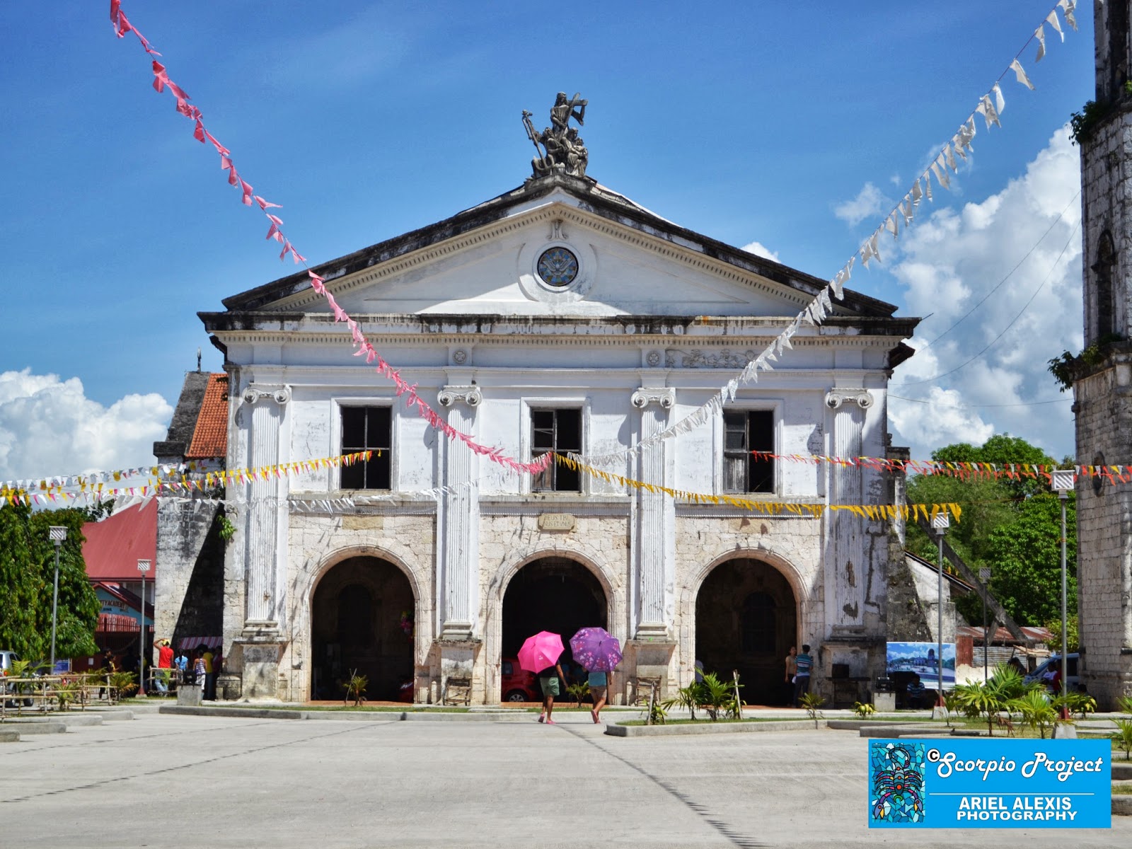


 Here’s one
city that’s bereft of natural resources yet still on the rise, capitalizing
mostly on the tourism boom to fuel its engines of socio-economic growth. Tagbi
is a showcase of Bohol’s economic metamorphosis in the last few decades as
evidenced by the business and commercial establishments that have sprouted. So
far, it has three large malls, and a handful of smaller shopping centers
offering a variety of goods and services, including two homegown mouth-watering
delicacies—Peanut Kisses and Edelweiss
Torta!
Here’s one
city that’s bereft of natural resources yet still on the rise, capitalizing
mostly on the tourism boom to fuel its engines of socio-economic growth. Tagbi
is a showcase of Bohol’s economic metamorphosis in the last few decades as
evidenced by the business and commercial establishments that have sprouted. So
far, it has three large malls, and a handful of smaller shopping centers
offering a variety of goods and services, including two homegown mouth-watering
delicacies—Peanut Kisses and Edelweiss
Torta! 
 Meander around museums and mansions. Though reeling from the stupor of the gruelling trip to Tagbi, I
mustered enough strength to get out of my hotel to catch some fresh air.
Reaching the town center, I walked around searching for a place to grab some
eats and scout for a tour guide-driver. Then, I found myself standing at the
doorsteps of the National Museum in Bohol where I got to see once again many
traces of the island’s colorful past.
Meander around museums and mansions. Though reeling from the stupor of the gruelling trip to Tagbi, I
mustered enough strength to get out of my hotel to catch some fresh air.
Reaching the town center, I walked around searching for a place to grab some
eats and scout for a tour guide-driver. Then, I found myself standing at the
doorsteps of the National Museum in Bohol where I got to see once again many
traces of the island’s colorful past.  History
buffs will find a trip to that historical bunker, once the home of President
Carlos Garcia, a delightful way to know more about the province and its
origins. Several memorabilia of the late chief executive, who happens to be one
of Bohol’s most revered sons, together with other historical, botanical,
zoological and archeological artifacts found in the province, are housed in the
museum.
History
buffs will find a trip to that historical bunker, once the home of President
Carlos Garcia, a delightful way to know more about the province and its
origins. Several memorabilia of the late chief executive, who happens to be one
of Bohol’s most revered sons, together with other historical, botanical,
zoological and archeological artifacts found in the province, are housed in the
museum.  It was my
second time to visit the provincial depository, which is located just a stone’s
throw away from the capitol, where I got to take another peek at the rarities
found inside. The brief tour left me in awe once again as I examined the artifacts
attesting to Bohol’s prehistoric past, including the two slabs of wood that
once formed part of a 500-year old house post of a pre-Spanish settlement and
the skeletal remains of a Boholana!
It was my
second time to visit the provincial depository, which is located just a stone’s
throw away from the capitol, where I got to take another peek at the rarities
found inside. The brief tour left me in awe once again as I examined the artifacts
attesting to Bohol’s prehistoric past, including the two slabs of wood that
once formed part of a 500-year old house post of a pre-Spanish settlement and
the skeletal remains of a Boholana! 

 Built in
1840, the house has been converted into a museum (under the auspices of the
National Historical Institute) showcasing several antique furniture and
memorabilia owned by the Clarins. Roaming around the house, I had a great time
going over several old stuff which I think badly needs preservation efforts if
only to protect them from the elements.
Built in
1840, the house has been converted into a museum (under the auspices of the
National Historical Institute) showcasing several antique furniture and
memorabilia owned by the Clarins. Roaming around the house, I had a great time
going over several old stuff which I think badly needs preservation efforts if
only to protect them from the elements. 

 Hunt down historic havens. Bohol made
a mark in Philippine history because of two major uprisings when we were under
Spain. I’m referring to the rebellions incited by Tamblot and Dagohoy, both
of which had the colonizers cracking their heads on how to quell the budding
insurrection taking place in various parts of the islands. It was these
revolts, numbering over a hundred for a long span of time, which somehow roused
our ancestors to turn the tables on the abusive Spanish regime.
Hunt down historic havens. Bohol made
a mark in Philippine history because of two major uprisings when we were under
Spain. I’m referring to the rebellions incited by Tamblot and Dagohoy, both
of which had the colonizers cracking their heads on how to quell the budding
insurrection taking place in various parts of the islands. It was these
revolts, numbering over a hundred for a long span of time, which somehow roused
our ancestors to turn the tables on the abusive Spanish regime. Led by a babaylan (indigenous leader functioning
as medicine man, seer, shaman and “miracle worker”), the Tamblot Uprising of
1621 stemmed from conflicts between the Filipinos’ old beliefs and the new
religion imposed by Spain. Though short-lived and unsuccessful, this religious
revolt is one of our earlier attempts to stand up against a foreign power.
Ironically, the Spaniards won by pitting an army composed mostly of Cebuano
soldiers against the Boholano rebels.
Led by a babaylan (indigenous leader functioning
as medicine man, seer, shaman and “miracle worker”), the Tamblot Uprising of
1621 stemmed from conflicts between the Filipinos’ old beliefs and the new
religion imposed by Spain. Though short-lived and unsuccessful, this religious
revolt is one of our earlier attempts to stand up against a foreign power.
Ironically, the Spaniards won by pitting an army composed mostly of Cebuano
soldiers against the Boholano rebels.  While
surfing the Internet, I chanced upon a pic of a monument supposedly dedicated
to Tamblot but it didn’t spell out the exact location. But there’s a wood
carving of Bohol’s folk hero which I stumbled upon while roaming around the
museum in Tagbi. If there’s none in the works yet, I hope Boholanos would put
up a prominent shrine for this intrepid babaylan who dared defy the colonizers.
While
surfing the Internet, I chanced upon a pic of a monument supposedly dedicated
to Tamblot but it didn’t spell out the exact location. But there’s a wood
carving of Bohol’s folk hero which I stumbled upon while roaming around the
museum in Tagbi. If there’s none in the works yet, I hope Boholanos would put
up a prominent shrine for this intrepid babaylan who dared defy the colonizers. 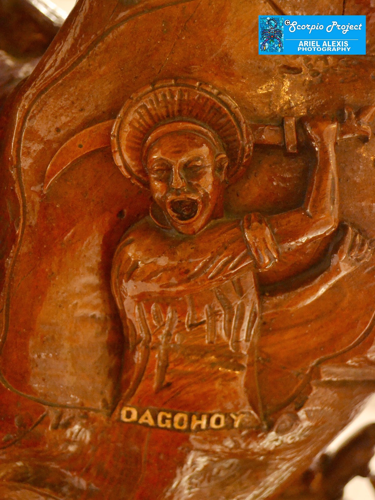 And who can
forget the Dagohoy Revolt of 1744-1829, which has gone down in our country’s
history as the longest rebellion ever? Instigated by Francisco Dagohoy, a
cabeza de barangay (village head) from the northern town of Inabanga, the
uprising (which lasted for 85 years!) resulted from the injustices that the
Jesuit priests inflicted upon the townspeople such as forced labor, excessive
tax collection and payment of tributes, to name a few.
And who can
forget the Dagohoy Revolt of 1744-1829, which has gone down in our country’s
history as the longest rebellion ever? Instigated by Francisco Dagohoy, a
cabeza de barangay (village head) from the northern town of Inabanga, the
uprising (which lasted for 85 years!) resulted from the injustices that the
Jesuit priests inflicted upon the townspeople such as forced labor, excessive
tax collection and payment of tributes, to name a few.  If I can
recall it right, it was the refusal of a Jesuit priest to give a Christian
burial to Dagohoy’s brother that served as the final straw that broke the
camel’s back, prompting Dagohoy to rally the Boholanos to rise up in arms
against the Spaniards. There’s supposedly a marker dedicated to Dagohoy in the
town of Danao. Too bad, it’s way out of my itinerary so I had to skip seeing
the shrine. Anyway, it’ll be one of my missions in my future visits.
If I can
recall it right, it was the refusal of a Jesuit priest to give a Christian
burial to Dagohoy’s brother that served as the final straw that broke the
camel’s back, prompting Dagohoy to rally the Boholanos to rise up in arms
against the Spaniards. There’s supposedly a marker dedicated to Dagohoy in the
town of Danao. Too bad, it’s way out of my itinerary so I had to skip seeing
the shrine. Anyway, it’ll be one of my missions in my future visits. 
 Burst into a beacon of bonding. There's
this historical shrine just outside Tagbi proper which I had the chance to see
during my very first visit to Bohol. The “bloody” landmark commemorates the
first international treaty of friendship between the early Filipinos and the
Europeans—the Blood Compact or Sandugo—involving Sikatuna, Bohol's chieftain,
and conquistador Miguel Lopez de Legazpi, representing the king of Spain, which
took place on March 16, 1565.
Burst into a beacon of bonding. There's
this historical shrine just outside Tagbi proper which I had the chance to see
during my very first visit to Bohol. The “bloody” landmark commemorates the
first international treaty of friendship between the early Filipinos and the
Europeans—the Blood Compact or Sandugo—involving Sikatuna, Bohol's chieftain,
and conquistador Miguel Lopez de Legazpi, representing the king of Spain, which
took place on March 16, 1565. 
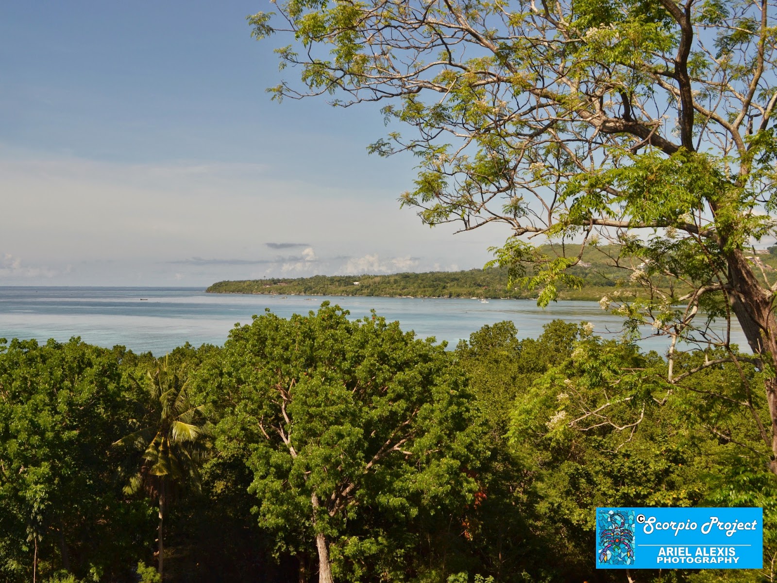 At that hour
of the morning, only a handful of tourists were around so I was able to engage
myself in a no-rush photoshoot with the life-size statues of the Sandugo’s main
protagonists. Braving the sweltering heat of the summer sun, I took shots all
over the shrine whose main feature includes the sculptures of five men gathered
around a table, with Sikatuna and Legazpi performing a toast. Julius also took
snaps of me together with the sculptures.
At that hour
of the morning, only a handful of tourists were around so I was able to engage
myself in a no-rush photoshoot with the life-size statues of the Sandugo’s main
protagonists. Braving the sweltering heat of the summer sun, I took shots all
over the shrine whose main feature includes the sculptures of five men gathered
around a table, with Sikatuna and Legazpi performing a toast. Julius also took
snaps of me together with the sculptures.  While
standing on the marble platform where the images are mounted, I was treated to
a picturesque vista of the Bohol Sea and the nearby island of Panglao. It was
one rare moment I managed to capture in my Nikon. Gazing at the stoic images, I
recalled the controversy among history writers surrounding this historic
moment.
While
standing on the marble platform where the images are mounted, I was treated to
a picturesque vista of the Bohol Sea and the nearby island of Panglao. It was
one rare moment I managed to capture in my Nikon. Gazing at the stoic images, I
recalled the controversy among history writers surrounding this historic
moment.  I wonder if the issue has already been settled. Anyway, I’m just a dabbler in history so I’d rather leave it to the experts to separate the factual from the fictitious. Whether it’s fact or fiction, Boholanos, however, continue to celebrate the historic bonding between Bohol’s king and the Spanish conquistador through the month-long celebration of Sandugo Festival held every July. Incidentally, sandugo means "one blood" in the vernacular.


